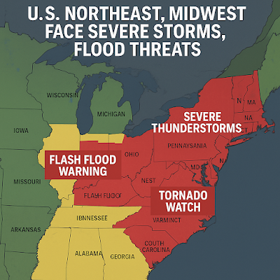
In July 2025, millions of residents across the U.S. Northeast and Midwest are grappling with extreme weather conditions, as a powerful system sweeps across the regions. The National Weather Service (NWS) has issued multiple alerts, including flash flood warnings, tornado watches, and thunderstorm threats. These weather events are causing travel disruptions, power outages, and increased risk to life and property.
 |
Severe Storm and Flood Alerts in U.S. Northeast and Midwest - Weather Map (July 2025)
| Storm Mapping |
As climate change intensifies, the frequency and severity of such weather systems are becoming more concerning. In this blog, we will cover the affected areas, weather predictions, safety precautions, and the potential impact on transportation, infrastructure, and communities.
Current Weather Situation:
The storm system currently affecting the Midwest and Northeast has developed from a stalled frontal boundary interacting with tropical moisture from the Gulf of Mexico. Meteorologists warn that the combination is leading to slow-moving, moisture-laden storms.
Key weather events include:
- Heavy Rainfall (2 to 5 inches): Forecasted across parts of Ohio, Pennsylvania, New York, and Vermont.
- Flash Flood Alerts: Issued for central and southern Illinois, Indiana, Kentucky, and parts of New England.
- Severe Thunderstorms: Including hail, lightning, and strong wind gusts exceeding 60 mph.
- Tornado Watches: Especially in the central Midwest regions including Iowa and Missouri.
Regions Most Affected
Midwest (Ohio, Illinois, Indiana, Iowa):
- Rivers like the Des Plaines and Ohio are at risk of breaching flood stages.
- Urban areas face overwhelmed drainage systems, causing street-level flooding.
- Crop damage concerns rise as storms affect major agricultural belts.
Northeast (New York, Pennsylvania, Vermont, Massachusetts):
- Steep terrain in Vermont and New Hampshire makes flash flooding more dangerous.
- Rail and road traffic face severe delays and closures.
- Flood watches have been extended for major rivers including the Hudson and Delaware.
Impact on Infrastructure and Daily Life
Transportation:
- Major interstates like I-80, I-70, and I-95 may experience closures due to flooded roadways.
- Air traffic has been delayed at major hubs including Chicago O’Hare, JFK, and Philadelphia International Airport.
- Amtrak and local transit systems are on high alert due to track washouts.
Power Outages:
- Over 200,000 homes and businesses are reported without power, primarily in Michigan and Pennsylvania.
- Utility crews are working round-the-clock, but access is hampered by storm debris and flooding.
Emergency Declarations and Government Response
Governors of several states, including New York, Illinois, and Pennsylvania, have activated emergency response teams. FEMA (Federal Emergency Management Agency) is monitoring the situation and has deployed rapid-response units in highly affected areas.
Local authorities urge residents to:
- Avoid unnecessary travel.
- Stay indoors and monitor emergency broadcasts.
- Keep emergency kits with water, batteries, and medical supplies.
Why These Storms Are Getting Worse: Climate Factor
Experts link the intensity of these storms to a changing climate. As global temperatures rise:
- Warmer air holds more moisture, leading to heavier rainfall.
- Changing jet stream patterns cause storms to stall, dumping more rain on localized areas.
- Urban development increases runoff and reduces natural drainage.
Safety Tips During Severe Storms and Floods
- Never drive through flooded roads. Just 6 inches of water can sweep a car away.
- Unplug electronics to avoid power surges during lightning.
- Move to higher ground if your area is prone to flooding.
- Prepare an emergency evacuation plan and keep documents waterproofed.
- Use weather apps and alerts from NWS, NOAA, or local services.
What to Expect Next (7-Day Forecast)
- Rain and storm activity is expected to taper off mid-week in the Midwest but will continue into late week in the Northeast.
- Flood risks remain high in low-lying areas and along river basins.
- Heat and humidity are likely to follow as skies clear, worsening health risks for vulnerable populations.
Conclusion
The ongoing severe weather crisis across the U.S. Northeast and Midwest is a wake-up call for both residents and policymakers. With increasing storms driven by climate change, preparedness and accurate information are more crucial than ever. Stay informed, stay safe, and follow local emergency services for real-time updates.
